‘Atmospheric river’ raises flood concerns in Whatcom lowlands this week
Heavy rain forecast over the next several days is raising the threat of flooding across Western Washington, including the Nooksack River in Whatcom County.
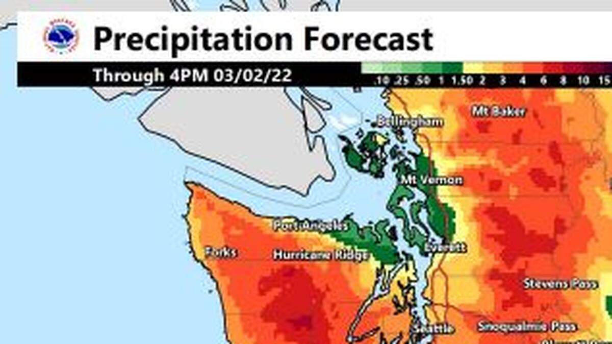
An “atmospheric river” of tropical storms is expected to drop 2 to 3 inches of rain in Bellingham and the Whatcom County lowlands through Wednesday, March 2, along with 4 to 8 inches in the North Cascades, the National Weather Service said in its online briefing Monday, Feb. 28.
“Heavy rain and rising snow levels will result in flooding for some area rivers, as well as localized urban/small stream flooding,” meteorologist Mary Butwin said online.
“Conditions will begin to ease slightly Tuesday, (March 1) but will remain unsettled for the rest of the week,” Butwin said.
February has been a relatively dry month in Western Washington, and the .18 inches measured at Bellingham International Airport on Sunday, Feb. 27, brought the monthly rainfall total to about one-third of normal.
But with another warm, wet storm on the way, a flood watch was in effect for Western Washington through 3 p.m. Wednesday.
It was just such a series of storms that caused widespread flooding in communities along the Nooksack River in January-February 2020 and in November 2021.
Rising levels are expected on rivers across Western Washington and some will reach major flood stage, Butwin said.
In Whatcom County, the Nooksack River is expected to crest below flood stage in Nugents Corner on Tuesday, according to current data from the Northwest River Forecast Center.
A crest about 1.5 feet foot below flood stage is expected on the Nooksack River at Ferndale on Wednesday.
Flooding was expected on the Skagit River in Concrete and Mount Vernon.
“River flooding may lead to isolated residential/urban flooding (with) widespread inundation of farmland (and) road closures possible,” the weather service said in its daily online briefing.
Heavy rain could block roads and cause delays with ferries and aviation.
“Widespread rain continues to the lowlands over the into early Tuesday. Heavy rain may lead to flooding in low-lying areas, underpasses, and areas with poor drainage. Ponding of water on roadways and poor visibility will lead to difficult travel conditions with high incident rates and/or travel delays by ground, air, or water,” the weather service said.
Meanwhile, snow continued to fall early Monday at the Mt. Baker Ski Area, with temperatures hovering around freezing.
Mt. Baker reported 25 inches of new snow over the past 24 hours at 5:30 a.m. Monday.
Avalanche danger was high in the Mount Baker wilderness, according to the Northwest Avalanche Center.
Snow levels were expected to rise above 6,000 feet on Monday, the National Weather Service said.
This story was originally published February 28, 2022 at 7:33 AM.
